Talo’fo’fo


View more images for the Talo’fo’fo entry here.
Steeped in history
The municipality of Talo’fo’fo is located in south-central Guam on the eastern coast of the island. The area extends from the shore and deep into the interior valleys along the Ugum and Talo’fo’fo Rivers. The Talo’fo’fo intersection is the crossroads of the main village, near which lie a few small stores, the San Miguel Catholic Church and the mayor’s offices. The Onward Talo’fo’fo Golf Resort lies east of the intersection, and afterwards, the road intersects with Route 17 or Cross Island Road. Heading south on Cross Island Road, one finds the Seventh Day Adventist Church and school, as well as Notre Dame High School, the subcommunity of Ipan and Talo’fo’fo Bay. The southern boundary of Talo’fo’fo is the Ugum River which, along with the Talo’fo’fo River, flows into Talo’fo’fo Bay.
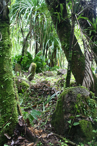
Guam’s southern terrain is largely volcanic, in contrast to the limestone plateau that dominates the northern part of the island. Grasslands, rolling hills and small limestone outcrops, as well as sandstone, and a red clay are part of the landscape found in the Talo’fo’fo vicinity. Several small rivers drain into the Talo’fo’fo River valley. In addition to the varied soil, the vegetation is also somewhat varied, including high grass, copses of limonchina and occasional large trees. Some of the wood areas include limonchina, vines, cycads, pandanus and ferns. The more marshy areas have wetland plants, such as reeds, coconut palm, bamboo and breadfruit, providing rich resources for Guam’s early inhabitants.
The name of the ancient village of Talo’fo’fo probably has its origin from the phrase “entalo’ i fe’fo’,” which means “between the cliffs,” or even from the word “fo’fo’,” which means a bubbling stream. An early historic map of Guam by Alonzo Lopez in 1671 show a village named “Taraiftofo” in the general area where Talo’fo’fo is located today. In addition to the waterways that traverse the area, Talo’fo’fo’s stunning landscape is comprised of rolling hills of clay, limestone and volcanic rock, grasslands and jungle, as well as caves, some noted for their size and ancient drawings, or pictographs, on the walls.
The interior lands of Talo’fo’fo are believed to have been occupied since at least 1,700 years ago–maybe as far back as 364 AD, according to carbon dates from the Talo’fo’fo Golf Resort area. Occupation continued through the Latte era, through the Spanish era to modern times with various levels of utilization of the land over time.
Archeologists believe most of the pre-Spanish era inhabitants lived in settlements along the Ugum and Talo’fo’fo Rivers. Artifacts in the Talo’fo’fo Caves indicate these sites were occupied and used as well, if only seasonally or for short periods at a time. Within the Talo’fo’fo vicinity were numerous named settlements, including Pigpug.
In 1678, the Spanish governor Captain Juan Antonio de Salas fought against the native Chamorros in the villages of “Picpuc” and “Tarafofo,” which were seen as the most arrogant of the southern villages to the Spanish soldiers and priests. The distance of these villages from the Spanish presidio in Hagåtña seemed to make the inhabitants more bold and less inclined to obey or comply with Spanish authorities. The Chamorros, aware of the impending battle, had set up ambushes and traps along the way. They rained lances and slingstones upon the invading Spanish soldiers but ultimately were defeated. After the Spanish reducción of the late 1600s which displaced the Chamorro natives from the northern villages and the other Mariana Islands, the residents of Talo’fo’fo were presumably shifted to Inalåhan and the main village was abandoned. Talo’fo’fo Bay, however, was the site of some recorded events in Guam’s history.
In 1788, the landing of a large group of islanders from Lamotrek in the Caroline Islands (now Yap State) occurred in Talo’fo’fo Bay. The Carolinians were on a trading mission to obtain iron. This landing, along with a landing in Haputo on the northwest coast, marked the first arrival of canoes from the other islands since the conquest of the Marianas by the Spanish. However, the Carolinian crew failed to return to Lamotrek. Although a storm probably led to their demise, on their home island they were believed to have been killed by the Spanish on Guam. In 1804 Luis de Torres, the son of a Spanish officer and a Chamorro woman, went to Lamotrek to invite the Carolinians to re-establish trade with Guam. Torres had befriended the original Carolinian sailors who had arrived in 1788. The trading voyages resumed the following year.
In 1849, a large earthquake was recorded on Guam and chronicled by Augustinian priest Ancieto Ibañez. The priest recounted a large wave had rolled into Talo’fo’fo and swept away Josefa Lujan of Hagatña, the only known fatality of the tsunami.
Years before the first American administration of Guam in the early 1900s, people had already been moving back into the Talo’fo’fo area to farm and hunt. Small plantations had been set up along the valley of the Talo’fo’fo River. Latte sites, however, still were visible in different parts of the valley, but were largely avoided. In 1912, a chapel supposedly was built close to the mouth of the Talo’fo’fo River. By 1918, the Naval governor William Gilmer appointed a commissioner for Talo’fo’fo, and the residents decided to move their village up to the plateau.
Traveling to and through Talo’fo’fo, however, was not easy. A small trail running along the coast connected Togcha Bay to the north and Dandan to the south. Bamboo rafts had been used to cross the river along the trail, which was eventually replaced by a ferry. In 1924, there is mention in the Guam Recorder that people from Talo’fo’fo were working without pay to build a road between the Talo’fo’fo and Togcha Rivers.
In 1931 the school in Talo’fo’fo was renamed in honor of Governor Gilmer. Although there was no road leading from the coast to the plateau, there was a relatively difficult foot trail. That same year a 135-foot bridge over Talo’fo’fo River was built, replacing the ferry. The building of the bridge helped to improve the transport of people and farm products from the south to the capital of Hagåtña.
Although Talo’fo’fo was previously considered part of Inalåhan by January 1931, Inalåhan was divided into two districts. Talo’fo’fo was designated north of the Talo’fo’fo, Ugum, As Mulato and Atate Rivers, while the district of Inalåhan was to the south. The Americans had set up a lookout post in Talo’fo’fo around this time. However, the area remained largely unoccupied, with few houses, and used mostly as ranch land.
During World War II, Talo’fo’fo Bay was one of the landing points for the invading Japanese forces on 10 December 1941, although the original landing site was supposed to be Ylig Bay, further north. After the invasion, the Japanese established a school in the village operated by the Japanese navy. By 1944, the Japanese had begun to fortify the island in anticipation of the arrival of American forces, and built gun placements and pillboxes in the cliffs near the bay. The Adjouilan Point pillbox, for example, is a Japanese pillbox on the north side of the entrance to Talafofo Bay. Ipan Point Pillbox lies north of Adjoulan Point. The As Quiroga fortification included two Japanese dummy gun emplacements, made of plywood and painted green. Another probable gun port is located in the Talo’fo’fo Rock Wall, formed out from a natural opening to a low cave in the raised limestone outcrop.
The wreck of the Aratama Maru, a Japanese freighter, is also located in Talo’fo’fo Bay. It had been used to transport supplies between Palau and the Marshall islands but had been attacked by US Naval submarines and drifted to Guam. (The vessel was listed in the National Register of Historic Places in 1988.) Shortly before the liberation of Guam, the Japanese destroyed the Talo’fo’fo bridge to deter the invading American forces.
After the war, the American military government built the new community of Talo’fo’fo in the hills where it now stands, establishing Talo’fo’fo as its own municipality. Although most of Talo’fo’fo today is still largely undeveloped, construction of concrete homes increased in the area, especially in the 1970s and 1980s. The Talo’fo’fo Golf Resort was built in the 1990s. In the early 1970s, Japanese straggler Sergeant Shoichi Yokoi was captured after 28 years hiding in the jungles of Talo’fo’fo, near Talo’fo’fo falls. Tourists can visit the area for a fee. Archeological surveys of the Talo’fo’fo Golf Resort area revealed another possible World War II stragglers’ cave, in addition to prehistoric scatters. Other tourist attractions in Talo’fo’fo include the jungle riverboat cruise which transports visitors inland from Talo’fo’fo Bay to a cultural village display and latte site. The inland hills are also popular for hiking and off-roading activities.
Previous archeological research
Much of the information provided below of archeological research in Talo’fo’fo is gleaned from reports done on the Talo’fo’fo Golf Resort and Route 4 construction projects. The first archeological work done in the Talo’fo’fo vicinity includes studies conducted by Hans Hornbostel who was employed by the Bernice Pauahi Bishop Museum in Honolulu Hawai`i in the 1920s. Hornbostel’s map of latte sites on the island showed seven dense clusters of latte in the island’s southern interior, including a large cluster along the lower Talo’fo’fo River valley. There were also latte clusters at Mapao and Acapulco, located in the Talo’fo’fo River valley. Hornbostel mapped other sites in what is now known collectively as Fena, adjacent to Talo’fo’fo. Anthropologist Laura Thompson later took Hornbostel’s field notes and published an analysis of the archeological findings for the Bishop Museum in the 1930s and discussed some of the variations of latte, pottery, and cave drawings found in Talo’fo’fo.
In the late 1940s, Navy archeologist Douglas Osborne was able to locate and examine several of the latte sites first visited by Hornbostel. He also studied latte sites in other parts of the island, including Humåtak and Tumon Bay/Gongna. Osborne declared that the most impressive latte sites on Guam were those of the southern interior areas, especially Acapulco, Mepo, Pulantat and San Isidro, and Mogfog in the north.
Osborne noted that the presence of Guam’s interior sites indicated that the coastal population had increased to the point that people needed to expand to settlements further inland. This increase occurred relatively recently and resulted in the small amounts of midden or artifact scatter generally found in interior sites–compared to coastal sites. He also suggested that the inland sites may have been only been used for special occasions or religious purposes and therefore were not occupied for extensive periods of time. Osborne also thought it possible that the Spanish may have destroyed large coastal latte sites during the reduccion, hence they were no longer prominent as the large latte in the interior. He also proposed that these interior sites were of more recent construction and represented places Chamorros had tried to escape to during the Chamorro-Spanish Wars of the late 1600s and early 1700s.
In 1952, National Park Service archeologist Erik Reed visited several of the sites observed by Osborne, including those that had been destroyed by the construction of Naval Magazine (Fena). Most of the latte clusters identified by the above researchers included between one and three latte; two sites, Acapulco and Mapao, contained more than four.
In the mid-1960s, Micronesian Area Research Center archeologist Fred Reinman identified 138 latte sites–37 in the northern part of Guam, and 101 in the south. Of the southern sites, eighteen were in the interior valleys and 29 in the interior uplands. The interior upland sites were typically situated on grassy knolls, forested ridges and at the heads of small drainage sites of inland rivers. The interior uplands, according to Reinman, had large numbers of latte structures, while other associated materials such as pottery, mortars and stone tools were relatively sparse, in contrast to coastal sites. Using Reinman’s data, today archeologists estimate that basalt mortars occurred at 33 percent of all interior upland sites, and only occur where latte were present. Stone tools were present at 70 percent of the sites and pottery sherds were present at nearly all sites as well.
Particular sites documented by Reinman in the 1960s include Asnite Bay, a small settlement along Route 4 extending from the cliffs to the beach. Scattered stone tool fragments and pottery sherds were found in the area. The site included a freshwater cave with pottery and other artifacts and rock shelters. Houses built in the area in recent years, however, have destroyed much of the site.
Another area referred to as North Asanite lies west of Route 4 and is another small settlement where pottery and stone tools fragments were found, as well as a freshwater sink. On the cliff north of Talo’fo’fo Bay is As Quiroga Cave which is essentially a series of caves and rock shelters that contained midden and pottery artifacts. Much of this site, too, has since been destroyed, but the caves contain pictographs (cave art) similar to those found at Gadao’s cave in Inalåhan. About 20 pictographs are visible, ranging in size from 5 to 20 cm. The cave was listed in the National Register of Historic Places in 1976.
The Talo’fo’fo Bay site itself had remains of five latte groups, three of which were still standing when Reniman observed them. The rest had been bulldozed when the land was cleared for farming. In addition to latte stones were mortars and pottery and stone tools.
Reinman also conducted work in the Talo’fo’fo River valley. Nine latte groups were recorded during Reinman’s survey, along with a number of stone mortars, pottery and tools. Also observed were rock shelters and caves along the cliffs. Human burials were found at the rock shelters. Reinman also visited the Picpuc/Pigpug site on the south of Talo’fo’fo Bay and the As Alonso River. This was a large settlement overlooking the sea and river, measuring about 500m by 1000m in area. Although Reinman saw no latte stones he did record mortars, pottery sherds, and stone and shell tools.
In the 1970s a study by TS Dye, et al., of two extensive complexes along the Bubulao River, reported latte clusters located on ridge crests with access to a variety of food plants, including coconut, breadfruit, federico palm (cycad) and betel nut palm. The archeologists suggested that the forest of food plants were cultivated by the inhabitants of the latte clusters. In addition, the presence of deposits of prehistoric ceramics in nearby savannah grasslands seemed to indicate that development and use of the savannah happened around the same time as the development and occupation of the latte clusters. Pottery types found in these sites would have likely been used to transport water from nearby streams for cultivation. Unlike Reinman, Dye believed the interior upland sites may have actually been more widespread and used more frequently but perhaps, the evidence of occupation was washed away by natural forces of erosion and subject to decomposition.
Recent archeological work
In the 1990s, archeologists from the Micronesian Archaeological Research Services (MARS) found culturally significant sites in Talo’fo’fo, including habitation sites in the ridge overlooking Talo’fo’fo Bay south of where the Ugum and Talo’fo’fo Rivers join. The sites date from 1480 to 1665 AD. A rock shelter/cave complex was also recorded on the inland side of Route 4 north of Talo’fo’fo Bay. Latte Phase pottery and both flaked and ground stone tools were collected. A limestone shelter was recorded with Latte Phase pottery and human bone.
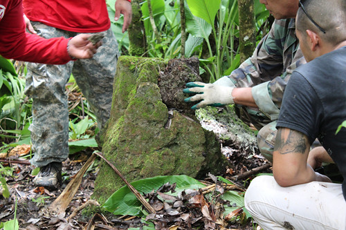
One of the most extensively studied areas in Talo’fo’fo was the land upon which the Talo’fo’fo Golf Resort was built. In the 1990s a team of archeologists from Paul H. Rosendahl, Inc., surveyed the land and made some general conclusions about sites in the vicinity of the project area. Some 24 habitation sites were identified or relocated within the project area, and revealed a variety of features including a cave shelter, latte site, hearth, and scatters of pottery and tool fragments. Carbon-dating provided dates as far back as 364 AD, but the area likely was occupied and utilized through the Latte era, and to an extent, up to modern times.
The archeologists suggested that most of the interior upland sites of southern Guam were occupied since 1000 AD but were probably also occasionally used during the pre-Latte period as well, based on pottery evidence. Sites with latte were probably more permanently occupied areas, and sites with no latte were likely only temporary or short-term occupation sites. These areas with no latte also were likely associated with other activities, such as gardening or for exploiting some of the area’s natural resources. In addition, latte structures seemed to have been built more around areas that were on or near soils suitable for agriculture and water.
The Talo’fo’fo area in particular probably was initially occupied during the late Transitional Pre-Latte to early Latte Phase (AD 384-891) because of evidence of human activity in soils that predate the construction of latte sets. The lack of associated artifacts and other “ecofactual” (significant artifact but untouched by humans) remains seem to indicate the area was only used for short-term, seasonal or temporary periods. However, by the early to middle Latte phases, the use of the area intensified. Occupation continued through the Latte phase (around 1500 AD) at which point the area was presumably abandoned with the arrival of the Spanish.
Most of the prehistoric activities in the Talo’fo’fo area include cooking, stone tool use and manufacture, food processing and craft production. Ceramic vessels may have been used to transport marine sources inland, collecting water or for other domestic functions. A number of historic artifacts were also recovered in the golf resort project area. The historic artifacts likely were the remains of military activities such as food preparation and consumption, fighting and other wartime activities, or were simply dumped or washed into the area.
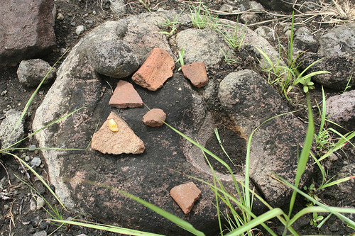
Prehistoric artifacts recovered in project areas in Talo’fo’fo include stone objects such as adzes and chisels, pestles, mortars, abraders, slingstones and flaked lithics. Interestingly, some stone tools appeared to have been re-used. For example, an adze used for chopping showed evidence of having been re-used as a hammerstone when the sharp edge of the adze became dull. Basalt pestles and large stone mortars with one central cavity and several smaller cavities were also found. Slingstones recovered in the area showed they were manufactured using largely available materials, including limestone, andesite and sandstone. Some slingstones showed they may have been used for other purposes besides weapons, such as for pounding as a hammerstone or pestle.
The collection of stone tools also give clues about the early methods of tool-making in the Marianas. The presence of flaked lithics suggested that tools actually were being manufactured in these areas. However, the tools were largely the kind with sharpened edges that could be made easily with basic hammerstrokes, which meant they were likely produced for expedient or immediate purposes. Lithic cores indicate the area was exploited for raw materials, especially basalt and chert which can be found locally. Groundstone tools, such as mortars and pestles, were also manufactured, but some mortars also could have been quarried off-site, nearer to other sources of raw material. Shell tools were also manufactured in some of these inland sites, but obviously, shell would have been procured elsewhere off-site.
Other activities implied by the presence of these tools is the processing of wood and fibers to make certain utilitarian objects such as baskets and mats. In addition, agricultural and subsistence activities such as food procurement, preparation and consumption are also likely to have occurred. There is also evidence of habitation and support activities in Talo’fo’fo in the form of latte sets and fire-altered rock. Slingstones could also indicate war activities, either between villages or between Chamorros and Spanish.
The majority of ceramics found in Talo’fo’fo are from the Latte Era. Although there was no evidence of particular areas used to manufacture pottery, the abundance of clays and tempering sediments make it highly likely that at least some ceramics could have been manufactured on-site. The thickness of vessel walls were seen to be thinner than contemporaneous ceramics from other parts of the Marianas. The need for thinner walls was probably based on the need to have lighter weight vessels to transport large quantities of water for the dryer areas further inland. Marine resources such as shell may also have been transported by these pots, but also may have been transported by woven baskets or bags.
Marine resources commonly found in the Talo’fo’fo area represent organisms that commonly inhabit shorelines or shallow-water areas and fringing reefs. Non-human, vertebrate remains found include carabao, pig, Guam deer, parrotfish, emperor fish and fruit bat. Archeologists suggest the inhabitants of the area used both marine and terrestrial resources. The terrestrial fauna were most likely the result of natural deposition in the area as opposed to prehistoric activity, as most of the mammals, with the exception of the fruitbat, were introduced to Guam after European colonization. In addition, inland sites such as Talo’fo’fo rarely produce faunal remains, largely because of the acidic soils and the extreme erosion. Agricultural activities such as farming and cattle grazing in recent years may have reduced the vegetation cover as well as exposure. Extensive defoliation also occurred during World War II to expose Japanese defense positions in the area.
The Talo’fo’fo area exhibits settlement patterns similar to other interior, upland sites. Shallow deposits of artifacts, food remains and human burials indicate recurrent short term, seasonal, or only recent occupation.
Historic Activities
Within the Talo’fo’fo Golf Resort area, several historic artifacts were recovered. These historic artifacts were mostly the remains from World War II activity. Cave sites in Talo’fo’fo were occupied during the war and have evidence of clothing, food containers and other military objects of both Japanese and American origin. A variety of metal fragments, including nails, iron spikes, hammer fragments and wire were also found. Domestic items, such as bottles and jars, ceramics, spoons, pots and cans, mostly associated with World War II, have also been recovered.
In the early 2000s, MARS archeologists worked on an area of Talo’fo’fo along Route 4 for the construction of a shore protection barrier. Although not much was gleaned in terms of significant cultural resources, the team did collect interesting oral histories regarding the area and the presence of a prewar cemetery that was used by Talo’fo’fo residents until the construction of the Catholic cemetery at Togcha.
According to accounts by residents, a burial ground was located between the bridge and the Talo’fo’fo Beach Park before the war and shortly after the war. The area, however, was prone to being washed over by large waves and indeed, several caskets were washed out in 1962 during Typhoon Karen. By the late 1960s, the remains were unsystematically moved to Togcha cemetery, though people used to lay wreaths and other memorabilia in the old site. However there is some uncertainty if all the bones had been moved and it is possible some burials remain.
For further reading
Pacicon (Guam) Corporation. Talofofo Golf Resort Project Area: Archaeological Mitigation Program Phases II and III: Data Recovery and Archaeological Monitoring: Talofofo Municipality, Territory of Guam. By Jack Henry, Martin Boudreau, and Alan Haun. Hilo: PHRI, 1994.
Reinman, Fred. Notes on an Archaeological Survey of Guam, Mariana Islands, 1965-1966. Mangilao: Micronesian Area Research Center, University of Guam, 1977.
Sea Engineering, Inc., Makai Research Pier. Archaeological and Historic/Cultural Investigation of the Guam Shore Protection Project, Talofofo. By Judith R. Amesbury, Darlene R. Moore and Rosalind L. Hunter-Anderson. Mangilao: Micronesian Archaeological Research Services, 2005
Thompson, Laura M. Archaeology of the Mariana Islands. Bernice P. Bishop Museum Bulletin, No. 100. Honolulu: Bishop Museum Press, 1932.