
Hagåtña
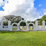
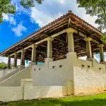
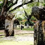
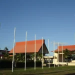
Table of Contents
Share This
Origin of village name in CHamoru
Hagåtña is derived from the word haga, meaning blood. It is believed that this village came about due to the bloodlines of the families that established the village. Appearing as “Agadña” or “Agaña” in Spanish maps, and later, “Agana” in American maps, the Guam Legislature in 1998 changed the official spelling to “Hagåtña” to reflect the original CHamoru/Chamorro pronunciation of the village’s name.
Population
As of the 2010 US Census, the village population was 1,051.
Village officials
The current mayor is Michael Thomas Cruz Gumataotao.
Village description
Hagåtña, located in central Guam, is nestled between Agana Bay and the cliffs of Agana Heights. It is considered the first European city in the Pacific because of the early colonization of the Marianas, as compared to the rest of the Pacific. It was declared a city by a Spanish royal decree 40 March 1686 as the capital of the Marianas, the residence of the Spanish governor and the site of the garrison.
Guam’s main roadway, Marine Corps Drive, runs through the village from east to west. Another major artery, Route 4, dissects the village from the shoreline to the central part of the island, running east. Hagåtña borders the village of Tamuning in the east and Asan to the west.
The capital of Guam, Hagåtña is the seat of the island’s three branches of government: Judicial, Legislative, and Executive as well as the religious center for the Catholic Church. It is also home to numerous commercial activities including legal offices, banks, department/variety stores, insurance, technical and professional services and restaurants.
The cultural resources of the village are significant being home to a large number of Guam’s historical sites. The Guam Museum, Hagåtña boat basin (formally known as the Gregorio D. Perez Marina), the Guam Public Library (formally the Nieves M. Flores Memorial Library) and numerous public facilities are also located within the village.
As opposed to the island’s historical past, Hagåtña is currently one of the least populated villages on the island. Residential homes primarily are located below the cliff at the western portion of the village.
Village history
Carbon dating indicates that the village was inhabited 2,630 years ago and possibly as long as 3,020 years ago. These dates indicate that Hagåtña was settled prior to the appearance of Latte, stone pillars and cup-shaped capstones, approximately 1,100 years ago. Little is known about the village during this time.
Ferdinand Magellan made landfall on Guam 6 March 1521, but it was not until 1565 that Miguel Lopez de Legazpi claimed the Mariana Islands for Spain. The Galleon Trade between Acapulco and Manila was established shortly after Legazpi’s arrival in Manila and passed regularly though the “Ladrone Islands.” Between Magellan’s visit and 1602, approximately 74 ships with as many as 300 people aboard passed through the islands, usually between Guam and Rota. The islanders began to anticipate the arrival of the ships and set out in their swift canoes to trade water and produce for iron.
During this period it is known that outsiders lived among the CHamoru people for long periods of time although there is scant information about the village of Hagåtña.
Whalers, pirates and traders
Until 1815 Spanish Galleons plied the waters between Rota and Guam conducting trade between Manila and Acapulco. At least 33 other non-Spanish ships are documented to have had contact with the islands during this same period. They were usually whalers, pirates preying on the Galleons, or traders.
Few detailed accounts of the village are known prior to the arrival of the Catholic mission headed by Father Diego Luis de San Vitores in 1668. San Vitores is credited with establishing the Catholic Church in the Mariana Islands. Shortly after arriving on the island of Guam, he renamed the village of Hagåtña, “San Ignacio de Agadña,” in honor of his holy father and patriarch.
At that time Hagåtña was reported to be the island’s principal village. It is estimated that 1,000 people lived in the village that reportedly had 203 dwellings: 53 upper-class homes and 150 other dwellings that belonged to lower caste residents “who had no part of the affairs of Agadña.”
San Vitores was initially welcomed by the island’s nobles, notably the principal Chief of Hagåtña, Chief Quipuha (Kepuha). In appreciation of his graciousness, Chief Quipuha was the first adult CHamoru to be baptized and was renamed Juan in honor of Saint John the Baptist, the patron saint of the island. Don Juan Quipuha as he was then called, is reported to have donated land in Hagåtña for the construction of the first Catholic Church and the house of the Society of Jesus. Upon his passing, he was buried beneath the altar of the Church. Some historians believe that the Dulce Nombre de Maria Cathedral Basilica was built on the site of this first Catholic Church.
Some have questioned the reason why the mission was established in Hagåtña. Father Francisco Garcia, who chronicled San Vitores’ life in 1683, states that Father San Vitores was called back to Hagåtña after visiting several villages on the island when the:
Nobles made it a point of honor that he live in their village. After all, the superior of all the fathers should live in the principal village. According to Garcia, Father San Vitores was not happy with this situation but made the best of it saying, ‘I am not a prisoner here without consolation, obeying the divine disposition of affairs as if it were the most glorious of missions.’ Garcia said, ‘But what the devil planned in order to block the spread of the Faith, the Lord used as a means to establish it more solidly. He [San Vitores] made Agadña the stronghold for Christianity in the islands, with a church and a house of the Society of Jesus.’
Violence erupted within a few months of the arrival of San Vitores, due to growing opposition to the missionaries’ teachings — which clashed with the traditional practices of the CHamorus. Sporadic fighting on Guam continued for 16 years with a final major uprising in 1684 when the hostile CHamoru faction tried unsuccessfully to drive the Spanish out once and for all, though uprisings continued in the northern Marianas until 1695. Spanish troops aided by newly baptized Catholic CHamorus were finally able to subdue resistance to the establishment of Guam as a Spanish colony.
From Spanish hands to American
During this time, Hagåtña remained the principal village of the island and eventually became the seat of the Spanish government. In 1687 it was formally named as a city and began to take on the characteristics of a Spanish capital. Hagåtña remained the seat of the Spanish government in the Mariana Islands until June of 1898 when Governor Juan Marina, his Spanish officers and military personnel surrendered their arms to Captain Henry Glass of the USS Charleston and boarded the ship as prisoners of war. All Spanish flags on the island were confiscated and the Americans departed without leaving a single American soldier on the island.
A little over a year later, the first regularly appointed American military governor, Richard P. Leary, arrived on Guam. While Governor Leary lived on board the ship for three months while the governor’s residence was being renovated, his aide William Safford took up residence in Hagåtña and in effect was the acting or Lieutenant Governor of Guam. Safford, a naturalist, kept a journal of his year-long residence on the island that provides detailed descriptions of the village of Hagåtña.
Arriving for the first time in the village of Hagåtña he observed:
Several streets diverging from the entrance to the town, more or less in the direction parallel to the beach and to the cliffs back of the town. Everything clean and tidy; best houses of masonry with tiled roofs, others of frame or bamboo thatched with coconut leaves or Nipa palm. All of them raised from the ground. Reached the Plaza de Magallanes, upon which face the Palace or Government House, and other public buildings including the Tribunal. Behind the Palace rises the steep escarpment of a plateau on the brink of which is an old fort and powder magazine now used as a signal station; on the west side of the plaza are the Public Treasury and the barracks of the native troops; on the east side the church, the palace and government store house are on the south side; and the tribunal and several private dwellings on the north side.
Between 1899 and 1941 Hagåtña became the seat of the American naval government. During this time improvements were made to the village and a new hospital was built. Entertainment centered around the Plaza de España, the old Spanish seat of government in the center of the village. The population of the village steadily grew from 7,432 in 1920 to more than 10,000 in 1940.
Japanese takeover
On 8 December 1941 World War II came to Guam. By December 10th the island was officially claimed by Japan and Hagåtña was renamed Akashi-shi. Akashi-shi became the headquarters of the Japanese administration. The Japanese occupation lasted about two and a half years.
American bombardment to retake the island began on June 16 and lasted for three weeks. Systematic bombardment began on July 8th. Hagåtña sustained major damage during this time. More than 1,200 homes were destroyed in addition to many public and private buildings. Numerous structures of historical significance also sustained major damage or were destroyed.
Post-war rebuilding
Post war was a time of rebuilding. Hagåtña again became the capital city of the US Territory of Guam. The rubble from the war was bulldozed into the sea to form the Paseo de Susanna. The federal government, and later the government of Guam condemned large tracts of land and redrew property lots in the village essentially redistributing villages resources. In some cases this action left original landowners without any property in the village. The village population plummeted from 10,004 in 1940 to only 800 in 1950, a ninety-two percent decrease.
By 1960 the population had grown to 1,642. The village reported the second highest median family income on the island with the largest group of workers engaged in wholesale or retail trades, professional services or public administration.
In 1962, a mandatory security clearance required of visitors to the island was lifted. The security clearance had been in place for 21 years and restricted entry to many including US citizens. The lifting of this security requirement brought about significant change to the island and the village of Hagåtña.
While Hagåtña had always been the center of government and commerce on the island, the new tourism industry shifted the focus from Hagåtña to Tumon. The island experienced a building boom as well as an increased presence of military personnel due to America’s entry into the Vietnam War. The population of Hagåtña grew to 2,119 by 1970 with the largest group of workers engaged as craftsmen and carpenters while the wholesale and retail trades reported 175 less workers than in 1960.
By 1980, the village population had shrunk to 896, climbing back to 1,100 by the year 2000.
A cultural revival in the 1990s spurred the renaming of the village to its traditional name, Hagåtña. Today, the village remains the seat of the island’s government as well as a center of commerce and trade. The village’s residential population is only a shadow of its former self. This fact combined with it’s significant historical and cultural heritage have fueled a movement to revitalize the island’s capital city. A master plan has been developed by the Hagåtña Restoration and Redevelopment Authority to revitalize, preserve and protect the heritage and economic vitality of Guam’s capital city.
Points of interest
Village map
Institutions
Academy of Our Lady of Guam
The island’s only all-girls Catholic school is located in the heart of Hagåtña. It was founded by the Sisters of Mercy, after Bishop Apollinaris Baumgartner asked them to establish Guam’s first permanent Catholic school. On 8 September 1949, the Sisters opened the doors to the Academy of Our Lady of Guam, a girls high school, and the Cathedral Grade School, a primary school for boys and girls, both located in Hagåtña.
Sister Mary Inez (Mary Essie Underwood) served as co-founder and first principal of both schools. While the Academy accepted students only for the ninth grade during that year, it eventually became a four-year high school. The school has educated several generations of Guam’s young women.
Historical
Senator Angel Leon Guerrero Santos Memorial Park/Latte Stone Park
This park was originally established during the administration of US appointed Governor Ford Quint Elvidge (1953 to 1956). The park was renamed the Senator Angel Leon Guerrero Santos Latte Memorial Park in 2005 in honor of the Guam Legislature senator’s efforts on behalf of the CHamoru people. Santos was a CHamoru rights activist and founding member of Nasion Chamoru, an indigenous activist group.
The park contains eight latte (stone pillars with capstones) transferred by the military from their original locations in the Me’pu and Fena regions in the southern interior of Guam as new military bases were being built in these locations.
Japanese World War II Caves
These caves, located at the base of the cliff line, were man-made with forced labor during the Japanese occupation during World War II. They were used for storage of supplies and shelter. One cave entrance is located directly behind the Latte Stone site at the Senator Angel Leon Guerrero Santos Latte Memorial Park.
Lujan House
Also known as the Guam Institute, the Lujan House is one of the few remaining pre-World War II houses in Hagåtña. The house was built in 1911 by Jose Pangelinan Lujan and was first used as a residence. In 1928 the Guam Institute, founded by Nieves M. Flores in 1922, moved to the Lujan House. Students paid a monthly fee of $1.00 in order to attend this private school. Among the many notable leaders that graduated from this school were Governor Ricardo J. Bordallo, Bishop Felixberto C. Flores and Judge Cristobal Duenas. The school was forced to close when the Japanese invaded the island in December 1941. The Guam Institute was listed on the National Register of Historic Places on 6 October 1977.
Plaza de España
The Plaza de España was the location of the Governor’s Palace during the Spanish occupation. Academics speculate that the plaza was established at its current location after a typhoon in 1693 destroyed Fort Santa María de Guadalupe, where the governor’s residence had been located since 1683. The Governor’s Palace served as the seat of government for both the Spanish and the first U.S. Naval Government. Most of the palace was destroyed by the shelling of Hagåtña during the retaking of Guam in World War II.
The historical structures of the Plaza de España that have survived until the 21st century include:
- The Garden House, which was built around 1736. Prior to World War II, it was used as storage shed to house garden tools for the Plaza de España. In 1954, the Guam Women’s Club, at the request of Governor Elvidge, re-established and staffed the Guam Museum within the Garden House, though it has since closed. The original Museum had been bombed during World War II.
- The Azotea and inner court are the only visible structure left of the Spanish palace. In 1933, the U.S. Naval Government built a tiered tin roof over the Azotea, which was originally an open terrace.
- The Chocolate House functioned as a merienda place, where the Spanish and American administrators of Guam and their families entertained, serving morning and afternoon beverages and pastries. The Chocolate House contains two of the oldest Spanish coat of arms on Guam. One is made from soft greenstone dated 1879; the other made of marble is dated 1895.
- The Almacen (Warehouse) Arches and Almacen flagstone floors — The remains of the former entrance to the palace warehouse, which later became an arsenal, and segments of the original floors are still present.
- The ruins of the walls built during Governor Muro’s administration, including the more that nine-foot walls behind the Azotea and the low walls behind the Plaza de España ruins, also remain standing.
The Plaza was listed on the National Register of Historic Places on 1 May 1974.
Dulce Nombre de Maria Cathedral-Basilica
The Cathedral-Basilica rests on the site of the first Roman Catholic mission in the Mariana Islands. CHamorus constructed the original wooden thatched chapel from 1669 to 1670 under the direction of Padre Diego Luís de San Vitores on lands granted by Chief Quipuha of Hagåtña. The CHamoru nobility initially welcomed San Vitores and his fellow priests. The chief of one of the mountain villages complained about letting strangers live in their land, but upon learning that the men were padres, he invited them to his village. Chief Quipuha was the first adult to be baptized, followed by all of the nobles of Hagåtña. Don Juan Quiphua, as he was called after he became a Christian, was the first to be buried beneath the church.
Significant dates/events in the history of the building of the Cathedral-Basilica:
- In 1705 through 1709, Governor Manuel Argüelles y Valdéz built a church of three naves in Hagåtña using blocks of coral from the sea.
- In 1862, Father Aniceto Ibanez constructed a beautiful chapel to the side of the existing church.
- In 1772, French Commander Crozet described the church as a “beautiful church of red brick and tile.”
- In 1912, the Iglesia de Dulce Nombre de Maria was designated a Cathedral. This structure survived until World War II when it was destroyed during the shelling of Hagåtña in preparation for the American invasion.
- In 1958, the present building was completed.
- In 1981, Pope John Paul II elevated the Cathedral to a minor Basilica.
- In 1998, the church underwent major renovations to include a museum gallery featuring exhibits of Guam history and culture and a gift shop.
One of the principal features of the Cathedral-Basilica is the statue of Santa Marian Kamalen. According to oral tradition, a fisherman off Cocos Island, Malesso‘ discovered the statue, during the late 17th century. It is believed that the statue, the patron saint of the Mariana Islands, washed up on the shores of Malesso’ in spite of its great weight.
By the mid 1800s, it was transferred and permanently housed at the Iglesia de Dulce Nombre de Maria.
Santo Papa as Juan Pablo Dos Monument
This bronze statue commemorates the 1981 visit by Pope John Paul II to Guam. This was the first papal visit to the island. The statue stands on a median on Chalan Santo Papa Juan Pablo Dos Street, named in his honor. It is the location where he held an outdoor Mass in February 1981. The bronze statute originally rotated one full turn every 12 hours; the motor no longer works.
Spanish Bridge
This stone bridge, also known as Tollai Acho (stone bridge in CHamoru), was built around 1800 during the Spanish administration of Governor Manuel Muro, and named after San Antonio de Padua. The bridge spanned the Hagåtña River, where it flowed before its course was greatly changed after the village was rebuilt, after World War II. On the south side of the bridge sits a bronze statue of La Sirena, Guam’s legendary mermaid.
The single span, arched bridge with stone abutments is located at Aspinall Street and Route 1. The bridge originally connected the districts of San Ignacio and Bilibic. The bridge was damaged during World War II and finally restored in 1966 with concrete. The bridge was listed on the National Register of Historic Sites on 6 September 1974.
Guam Museum
The Guam Museum, located at Skinner Plaza in the heart of Hagåtña, Guam, is a government of Guam owned museum focused on the history of Guam. Its official name is Senator Antonio M. Palomo Guam Museum and Educational Facility.
The Guam Museum, opened in 2016, reflects the diversity, creativity, and resilience of Guam and the Mariana Islands. It is hoped to encourage people to engage in dialogue, to share multiple perspectives and experiences, and debate issues that concern us all today.
Guam Congress Building
The newly-restored Guam Congress Building holds the legislative session hall, hearing rooms, and offices of the island’s senators. The Guam Legislature returned to the building, after more than 25 years of absence, in January 2017, after reconstruction finished in December 2016.
The building is the site of the historic Guam Congress walk-out, which led to the passage of the Organic Act of Guam in 1950.
Village mayors/commissioners
- Michael Thomas Cruz Gumataotao, Mayor, 2025-Present
- John A. Cruz, Mayor, 2005-2024
- Felix F. Ungacta, Commissioner/Mayor, 1981-2005
- Thomas F. Mendiola, Commissioner, 1973-1981
- Lucas L. San Nicolas, Commissioner, 1962-1973
- Juan D. Perez, Commissioner, 1952-1962
- Antonio Suarez, Commissioner, 1918-1930
- Joaquin Cruz Perez, Commissioner, 1894-1899
Deputy commissioners
- Vicente dela Cruz, Deputy Commissioner, (no date provided)
- Lorenzo Franquez, Deputy Commissioner, 1930
- Lucas de Castro, Deputy Commissioner, (no date provided)
- Jesus de Rivera, Deputy Commissioner, (no date provided)
- Antonio Guerrero, Deputy Commissioner, 1832-1834
Editor’s note: The preceding list was provided by Konsehelon Mahot Guåhan/the Mayor’s Council of Guam.
For further reading
Anonymous. The Social-Economic Impact of Modern Technology Upon a Developing Insular Region: Guam. Mangilao: University of Guam, 1975.
Apple, Russell A. Guam: Two Invasions and Three Military Occupations: A Historical Summary of War in the Pacific National Historical Park, Guam. Mangilao: Richard F. Taitano Micronesian Area Research Center, University of Guam, 1980.
Driver, Marjorie G., and Francis X. Hezel, SJ. El Palacio: The Spanish Palace in Agana, 1668-1898. MARC Education Series no. 26. Mangilao: Richard F. Taitano Micronesian Area Research Center, University of Guam, 2004.
Freycinet, Louis Claude Desaulses de. An Account of the Corvette L’Uraine’s Sojourn at the Mariana Islands, 1819. Translated by Glynn Barratt. Saipan: Commonwealth of the Northern Mariana Islands Division of Historic Preservation, 2003.
Freycinet, Rose Marie Pinon de. A Woman of Courage: The Journal of Rose de Freycinet on Her Voyage Around the World, 1817-1820. Canberra: National Library of Australia, 1996.
García, Francisco. The Life and Martyrdom of Diego Luis de San Vitores, S.J. Translated by Margaret M. Higgins, Felicia Plaza, and Juan MH Ledesma. Edited by James A. McDonough. MARC Monograph Series 3. Mangilao: Micronesian Area Research Center, University of Guam, 2004.
Mayors Council of Guam. “MCOG – Mayors Council of Guam.”
Onedera, Peter R., ed. Nå’an Lugåt Siha gi ya Guåhan (Guam Place Names). Hagåtña: Chamorro Language Commission, 1988.
Safford, William E. A Year on the Island of Guam: An Account of the First American Administration. Washington, DC: HL McQueen, 1910.