Resettlement Patterns Under American Rule


-Spanish Wars, a century earlier.
Balthazar Aguon")
")


")


Editor’s note: The Historic Resources Division of the Guam Department of Parks and Recreation contracted Micronesian Archaeological Research Services to compile an architectural history, utilizing archival research and oral history interviews, of Guam’s eight postwar resettlement villages, Agana Heights, (New) Hågat, Barrigada, Dededo, Sånta Rita-Sumai, Sinajana, Talo’fo’fo, and Yona. The following is a condensed version of their report which focuses on the villages that were resettled after the war. The full report is available at the Guam Department of Parks and Recreation.
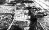
Villages relocated after World War II
Resettlement Village Histories
Throughout the 19th century, northern Guam had always had about five times more residents than did southern Guam, largely due to the population concentrated in Hagåtña, and in the 20th century, the north continued to support many more people than the south.
The first three decades of American rule saw slow growth in Guam’s population in all the villages, recovering from several devastating epidemics in the 1800s. In 1901 the island had 9,676 persons, and in 1910 the population had increased to 11,806. In 1920 it had grown to about 13,500 and in 1930 it was 18,509.
By the 1920s, eight municipalities had been established by the naval government. These were Hagåtña (which contained present Agana Heights, Barrigada, Chalan-Pago-Ordot, Dededo, Hagåtña, Mangilao, Mongmong-Toto-Maite, Sinajana, Tamuning, and Yigo); Hågat (which contained part of what is presently Sånta Rita-Sumai); Asan; Inalåhan (which contained present-day Talofo’fo’); Malesso’ (which contained present-day Humåtak); Piti; Sumai; and Yona. Thus, of the eight resettlement villages in the present study, only Yona was considered a single municipal entity at this time.
In 1939, Guam’s population of about 22,843 people lived in 15 municipalities. After the war, two municipalities were lost, the land taken by the US military for various facilities. The lost municipalities were Machanao in the northern end of the island, with a dispersed population of 274 in 1940, and Sumai on Orote Peninsula, with nearly 2,000 residents in 1940.
Even greater changes happened in Hagåtña, the most populous of Guam’s municipalities before the war, with about 10,000 residents in 1940. Declared off-limits to resettlement, former Hagåtña residents moved into the areas where they had maintained lanchos (ranches) before the war, especially Agana Heights, Sinajana, and Barrigada.
Just before the outbreak of World War II, in 1939 Guam’s population had risen to 22,843. Among the resettlement villages for which separate populations were distinguished in 1939, Hågat had 1,126 persons; Barrigada 724; Dededo 1,529; Sinajana 1,180; Talofo’fo’ 512; and, Yona, 720.
As noted above, these villages had undergone considerable changes in population by 1950. In 1946 the totals were: Hågat and Sånta Rita-Sumai combined (reflecting the loss of Sumai) 2,620; Barrigada 3,231; Dededo (with Tamuning) 1,818; Sinajana (reflecting displaced Hagåtña residents) 7,547; Talo’fo’fo 726; and, Yona 1,156.
Following the war, the resettlement process increased the population totals in several villages without upsetting the steady increase. However, Hagåtña, unlike Guam’s other villages, was radically depopulated after the war. Accordingly, the percent population decrease in Hagåtña from 1940 to 1950 was -92.0. In contrast, the percent increase in population over the same decade in Hågat was 338.4, in Barrigada it was 1,218.2, in Dededo it was 438.5, in Sinajana it was 641.8, in Talo’fo’fo it was 100.2, and in Yona it was 111.4.
Each of the eight resettlement villages had undergone the resettlement process according to its own unique socio-cultural, historical, and physical circumstances, just as each individual and family had unique personal experiences during this time. Accordingly, the brief village histories provided here contain a variety of information, not always comparable from one to another. Nonetheless, a shared demographic, economic and political history also unites the villages of Guam.
Agana Heights
Before the war the area known as Tutujan as well many scattered ranches, some owned by people who maintained residences in Hagåtña, were located where Agana Heights is now. Coconut palms were abundant in this part of Agana Heights before the war and people in Hagåtña often came to the area (presumably to their ranches) to cut fronds to use as roofing material and for other purposes.
A landmark located in Agana Heights is the Spanish Fort, Fort Agueda, also known locally as “Ft. Apugan.” Overlooking Hagåtña, it was used by the Japanese during World War II. The fort has been restored and is now a tourist attraction. Apugan in the Chamorro language (native language of Guam) means ashes and refers to the custom of burning fires to help guide canoes into Agaña Bay.
During the immediate resettlement period, the US Island Command headquarters was located in Agana Heights along with a stockade that held Japanese prisoners of war. The stockade was in the vicinity of the present Naval Hospital Guam. Tony Palomo described the stockade:
A large enclosure, surrounded by a double twelve-foot wire fence…, about a hundred yards from the Island Command headquarters. About fifty tents and two watch towers were built within the enclosure, and an administrative and interrogation office were constructed near the entrance to the stockade.
War crime trials were held in Agana Heights after the war, and the court and the stockade were closed in 1949. The navy governor’s house was located in the present naval hospital area as was the armed forces radio station. On Apugan and Tutujan, above Hagåtña, US Navy and Marine Corps officers and enlisted men assigned to work for civilian affairs pitched their tents and commuted daily between Hagåtña and their camp site.
The Catholic Church in Agana Heights, Our Lady of the Blessed Sacrament, was the first modern concrete church to be built on Guam after the war. It had a tin roof and ifil wood inside. One of the first baseball fields was built in Agana Heights. The Elks’ Club and the Scottish Rite Temple in Agana Heights were first built in the 1950s.
Hågat
Before the war, Hågat’s population lived in the area now known as old Hågat. In 1939, the village had a population of 1,126 people. They lived in the village and farmed outlying areas including Fena. The Catholic church, Mt. Carmel, was located on the site of the present-day 76 gas station. Across the street from the small Spanish-style, stone-based church was the public elementary school, built on land donated by Catholic Bishop Elias. The old cemetery is situated on the shoreline south of the former school, where the Togcha River presently debouches. On the beach just north of the old cemetery was the only public bathroom in Hågat before the war. It was on land owned by the Carbullido family. When the Japanese took over in 1941, soldiers lived in the Carbullidos’ house. The shoreline from the Namo toward Nimitz Beach is called Salinas, from the pre-war custom of making sea salt by boiling. The process was carried out in little shacks along the beach.
After the war, several parts of Hågat were taken by the military government and utilized for various purposes. In the summer of 1944 a refugee camp was created at Camp Bright, on Orote Peninsula and along the shoreline north of Hågat. A few weeks later the people at Camp Bright were moved to the Gaan Point area where they built A-frame houses with one or two rooms from a variety of materials.
For example, supports were posts cut from ifit (Intsia bijuga), gagu (Casuarina equisetifolia) and other trees, coconut tree trunks, and old telephone poles. Roofs and sometimes the walls were woven coconut fronds or pandanus. Some of the houses had walls of rough lumber and scrap wood, referred to locally as “dunnage lumber,” obtained from military shipping pallets. The houses were laid out in rows in three residential sections. Floors were elevated about two feet off the ground, and there was no plumbing.
Gaan Point camp was occupied from 1944 to 1946. Various government facilities were built at the camp, closer to the shore than the houses. There was a school and a church and a long building that had a dispensary at one end and government offices at the other. One of these offices was that of the “time keeper,” who kept track of government workers’ hours; many people worked for the military at this time. Three laundries, one for each of the three camp sections, were located near the government offices. The navy put up latrines near the beach in what is now called a pillbox, one for women and one for men. Former Mayor Tony Babauta recalled that because the latrine was so far from the houses, it was next to impossible to reach it in time when one had diarrhea, and many suffered from that affliction then.
When Typhoon Querida was about to hit Guam, the people at Gaan Point were bused to safety to what was called Base 18 in Apra Heights. Not all the houses at Gaan Point were destroyed by Querida, but by then the block system was being laid out. Village commissioners decided which family would be assigned to a given lot.
Other military facilities created in the area after the war include the US Naval Supply Depot, which took up vast areas of land around Apra Harbor and Sumai, and military encampments at the present Nimitz Beach and by the present Seventh-Day Adventist Church on the inland side of Route. 2. The supply depot employed many civilians from Hågat and Sumai early in the postwar period.
Later, to accommodate thousands of Filipino laborers working on military construction projects, Camp Roxas was built adjacent to Naval Station, on land formerly owned by the Bordallo family. The camp was abandoned in the 1950s, but many of the Filipinos who had lived at Camp Roxas became American citizens and eventually built homes in the old Hågat area, where their families live today.
The construction and expansion of the naval magazine at Fena and the building of Fena reservoir, took much of the farming and collecting areas that had been used by Hågat families before the war.
Island Commander, Marine Major Gen. Henry L. Larsen, and the City Planning Commission devised a plan for the rebuilding of Hågat. The plan was reported in an illustrated article in the Navy News Sunday supplement on 10 February 1946. In the article, Hågat was to be “the first village to be reconstructed under the plans to rebuild Guam.” A 180-acre tract of land in New Hågat “opposite the site of the existing village” was to be used, and three house designs were suggested, “designed objectively for Guamanians” by Navy Commander Allan T. Squire. According to the announcement in the Navy Times, these houses would be built as models.
The “Type A” model house was a simple tin-roofed wood frame house without indoor plumbing, estimated to cost between $700 and $1,350. “House Type B’ was a typhoon-proof house built of concrete blocks and concrete slab roofing, with indoor plumbing and estimated to cost between $1,700 and $2,400. “House Type C” was to be larger, also typhoon-proof, built of concrete blocks and wood with a concrete floor with indoor plumbing and estimated to cost between $1,800 and $2,700.
A large plaza overlooking the ocean was planned for New Hågat as well; the plaza would contain buildings to house a bank, post office, commissioner’s office, dispensary, library, primary school for 300 pupils and auditorium/municipal hall; stores would include a barber shop, beauty shop, cobbler shop, bakery, general provisions, and restaurant with bus terminal; even an outdoor theater, to be built with private funds, was included in the plan. The houses were to be financed through loans made with the Bank of Guam (then run by the Navy), amounting to about 60 percent of the total cost of house and lot; loans were to be amortized over five to twelve years.
Typhoon Querida struck in September of 1946 and many of these plans were shelved.
The Navy News article stated that road construction in New Hågat had begun and that lots could be allocated within four-to-six weeks. The lot allocation system would give priority to Old Hågat residents and those who had owned land in the 180-acre tract.
In the grid-like layout of New Hågat, which was typical of the military housing designs beginning with the first refugee camps, a series of twenty-nine blocks was created on relatively flat land on the inland side of Rt. 2, formerly known as Cereen Street. Individual lots within the blocks were numbered and were assigned to families by the village commissioners (generally the same individuals who had been in office prior to the war). Family members tended to request adjacent lots, perpetuating the pre-war village residence pattern (possibly an even older cultural preference) wherein the dwellings of extended families tended to cluster in space, forming compounds.
During the 1950s, people were building houses using a variety of means, including private contractors (some from the ranks of skilled carpenters and masons brought from the Philippines to work on government projects) and family members and friends with carpentry skills. There were three construction contractors operating in Hågat in the 1950s: Lapid, Quitugua and Samar. These houses were small, single-storey, flat-roofed concrete structures, to which people could add over time as their means permitted.
Barrigada
In 1940 Barrigada was an agricultural area and had a population of 875 people who lived in widely dispersed farms. At that time, Barrigada’s church, school, and Guam’s first drilled well, with a concrete water reservoir, were located on the road (Route 8 ) that now leads to the former Navy golf course in the area known as Radio Barrigada.
In mid-1943, farmlands in Barrigada, as elsewhere in Guam, were taken over by the WWII Japanese government, to grow food crops for Japanese soldiers. Farms were opened or expanded around schools, where the teachers and students labored to increase vegetable production. There was a garden around the Barrigada School where beans, yams, breadfruit, and coconuts were planted. Throughout the war, many families stayed on their ranches in Barrigada, where they managed to eke out a living from the land.
During the resettlement period, Barrigada’s population increased from its pre-war figures. This was largely due to the fact that some of Hagåtña’s pre-war population moved to this village, in part because they probably had ranches in this area before the war. The population increased from 875 people in 1940 to 3,231 in 1946, a 270 percent increase.
At first people returned to the area where they had been before the war, in the area now known as Radio Barrigada. During the immediate resettlement period, people constructed shelters from a combination of salvaged and local materials.
In addition to homes, a number of small businesses, including stores and restaurants, were built along the road (now called Route 8). However, as the military took land for military facilities, a golf course, and the antenna field, displaced people settled within the area around the present San Vicente Catholic Church and the mayor’s office. In this area the navy laid out new streets and lots.
Although the navy intended to condemn all of the land in Old Barrigada, some local families persuaded the navy to let them retain some of their land.
The first San Vicente Church, built of wood, was dedicated on 13 April 1947. To cover the cost of building the wooden church, the people of Barrigada raised funds, the village men donated labor, and the women cooked and fed them. This wooden structure was later replaced by a modern concrete structure.
In 1948 private land in parts of Old Barrigada, adjacent to what is now known as Radio Barrigada, part of the Navy’s communications facility was released back to private owners, but much of the former farm land was retained by the government.
Dededo
Prior to WWII, the village of Dededo proper was located south of its present location near the old San Miguel Brewery on Route 16. In 1940, it had a population of 1,196 including Tamuning.
During the resettlement phase, when the military decided it needed the former village area for Harmon Airfield and associated facilities, they moved the village center to its present location in an area known as Liguan where a few scattered ranches had been located. In this area was built a mayor’s office, fire-station, church (Santa Barbara Catholic Church) and school.
In 1946, the population of Dededo had grown to 1,818 people (including residents of Tamuning).
In addition to Harmon Airfield, with its military dependents’ housing in the Upper and Lower Harmon areas, there were several other military camps in the Dededo area. For example, the army had a military establishment in the area now known as Marbo. Camp Edusa, built adjacent to the Marbo camp, housed the Filipino workers brought to Guam to work on military projects in the 1940s and 1950s. Many of these people stayed on Guam and eventually settled in the Dededo area.
Sånta Rita-Sumai
Before the war, the area of Sånta Rita-Sumai was unoccupied and the land was owned primarily by the Bordallo family. The village was built to house the former residents of Sumai. The farming areas for the Sumai residents were the Atantano River Valley and the Piti area. During WWII, the people of Sumai municipality, the second largest pre-war town on Guam with close to 2,000 people, were forced to evacuate their village on Orote Peninsula.
When the Japanese took over Sumai, the people were told to tear down their houses and move, or rebuild them in Apla, an area was located on the isthmus of Orote Peninsula.
After the recapture of the island in 1944, the Sumai people were initially housed in military tents at Camp Bright (on Orote). From there they were moved to the Hågat Refugee Camp. The refugee camps were established to keep people safe from attacks by armed Japanese stragglers.
Once the US military decided to use the Apla area for military purposes, the displaced people of Sumai were told to move to the village of New Hāgat. However, because of old rivalries with that village, they demanded another location. The military authorities agreed and in 1945 the Sumai people moved to a new village, Sånta Rita-Sumai, which was located up the hill some distance away from Hågat.
About half the people who had lived in Sumai moved to Sånta Rita-Sumai and the other half moved to the Toto/Mongmong area. Those that moved to Sånta Rita-Sumai worked for the navy at Orote Peninsula. Those who moved to the Toto/Mongmong area worked in navy camps in that area. It was the Fifth Field Depot that covered much of the Maite, Mongmong, Toto area in 1944-45. Elephant Quonset huts were erected all along Route 8 (the Hagåtña-Barrigada Road). The workers at Toto stayed in large tents.
Sånta Rita-Sumai was laid out in blocks and lots, although the hilly terrain resulted in less regularity in lot shape than the New Hågat lots. Lots within the blocks were assigned to families by the village commissioners. The hilly terrain was not really suitable for a village site in that there were drainage problems that caused erosion and land slumps.
The first houses built in Sånta Rita-Sumai were duplexes made of scrap lumber, some gathered from the military. Some of the scrap lumber came from military ammunition crates. The navy built a shower and laundry structure for the villagers and fresh water came from a pre-war waterline. The marines had a Quonset-hut office in the village and they were assigned to provide security to the villagers. The first post-war church in Sånta Rita-Sumai, Our Lady of Guadalupe, was also built of scrap lumber and everyone in the village pitched in to help build it.
Sinajana
Before the war people lived in the Sinajana area and the village had a population of 1,236 in 1940. Most of the houses were on either side of the main road (now known as Route 4), approximately located from the area of the present-day Ace Hardware south to the present-day Butler family buildings. Sinajana used to be a planting/farming area for residents of Hagåtña.
The Catholic Church, St. Jude’s, is located where it has always been. The church was built in this locality so that its steeple could be seen from almost anywhere in the village. After the war, the village developed around the church with the mayor’s office and the fire station built nearby.
During the resettlement period, the population increased so that the village became the largest post-war village with a population of 7,547 in 1946. Part of the reason for the population expansion was the number of Hagåtña families who relocated to Sinajana from 1944 to 1946.
Talo’fo’fo
Before WWII people lived on scattered ranches in the Talo’fo’fo area. At the time, San Miguel Catholic Church was located in the vicinity of where Notre Dame High School now stands. The pre-war naval government established the village of Talo’fo’fo (formerly included within the Inalåhan District) as an “agricultural community.”
During the resettlement period, a refugee camp was set up in Talo’fo’fo and it accommodated 13 families, comprising 105 people on 11 September 1944. Although the exact location of the camp is unknown, it may have been located in the As Lucas area of Talo’fo’fo. Approximately 142 laborers were brought in and billeted at the camp on 18 September 1944. Bags of drinking water were brought in and latrines were dug, but a shortage of lumber made it difficult to finish the latrines. In 1946, Talo’fo’fo was still considered to be an agricultural area and it had a population of 726.
During the resettlement period the village center was moved to its present location and the navy built a concrete structure to serve as a dispensary. That structure now houses the village mayor’s office, perhaps one of the oldest buildings in the village.
There are still concrete sentry post, entrance gates, and concrete slabs that once formed part of Camp Dealy located in Ipan in 1944-45. The Cruz family now lives in several concrete houses in the Camp Dealy area on Beck Ping Road.
Farther north, in the area now known as Pirate’s Cove, there was a Pilot Rehabilitation Camp, probably called Camp Ethridge. In April 1945 this camp consisted of a beer garden, softball diamonds, volleyball courts, and horseshoe pitching fields. By October 1945, the camp had expanded to include a swimming pool, a basketball court, a theater, picnic areas, and a skeet range. After the camp was abandoned by the military, an Ipan man, Jimmy Cruz, operated a bar called Pirate’s Cove in one of the old wooden buildings. Jeff Pleadwell took over this facility in 1979 after Cruz died, and rebuilt the structure now known as Jeff’s Pirate’s Cove.
Yona
Pre-war Yona residents lived on scattered ranches in the area and coconut plantations were abundant, especially in the area later taken over by the military for Camp Witek. According to Mayor Jose “Pedo” Terlaje, Santiago Leon Guerrero Cruz had a big coconut plantation and oil production facilities (for soap, cooking and medicinal oil) in the area now known as Witek. In 1940, the population of the village was 656. In 1946, the population increased to 1,156.
During the resettlement process, the village center remained near its former location which was near the present-day St. Francis Catholic Church fronting Route 4.
The mayor’s office and a fire-station are located on the opposite side of the street from the church. When the mayor’s office was first set up after the war, it was in a Quonset hut, along with the dispensary.
Camp Witek was located seaward (east) of Route 4 on the elevated portion of Yona proper and it served as a station for members of the First Provisional Marine Brigade and the First Provisional Combat Service Group. The base consisted almost entirely of Quonset huts that housed military personnel and their dependents. At its peak, a total of 3,798 Marines were stationed at Camp Witek. The base was abandoned in 1950. Portions of the camp later served as a housing area for government employees. Eventually the property was returned to its original owners.
In addition to creating the large facility at Camp Witek, the US military partially built, but then abandoned, a large complex of concrete barracks and support facilities at the Torres (Aguilat) property in Yona near today’s Windward Hills Estates and Baza Gardens subdivisions.
Manenggon Concentration Camp, later the Manenggon Refugee Camp, was located along the Ylig River, southwest of Yona proper. Living at the camp in September 1944 were as many as 2,800 Chamorros. The exact date of the camp’s closure is unknown, but one internee, Catalina Baza, claims to have lived at Manenggon approximately three months, which would have been until early October 1944.
By Micronesian Archaeological Research Services